 |
|
|
|
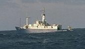
Figure B: Some of the observing
facilities that took part to the field phase of FASTEX. From
top to bottom: the 3 aircraft based in Shannon, Ireland (owned
by US NOAA and NCAR, operated with french and US funds), the
US oceanographic ship Knorr seen from the french oceanographic
ship Le Suroît, the launch of a radiosonde from the ukrainian
weather ship Bugaev in mid-ocean. (Photos: N. Raynal, A.
Butet and T. Douffet, from Météo-France.) |
|
|
The
areas of particular interest to FASTEX are:
- a remarkable, if somewhat worrying, property
of mid-latitude cyclones is that, on the daily weather time scale,
they successfully challenge the state-of-the-art forecasting
techniques of the moment, and this has been going on for more
than a hundred years; in other words, in the presence of the
risk of rapid cyclogenesis, the predictability of the atmosphere
drops dramatically, we are nearly completely blind even to its
immediate future, and progress in this particular domain is very,
very slow; scientists are, however, beginning to understand why
this is so; an enterely new approach of observation combined
to the most recent data assimilation techniques may allow a decisive
breakthrough and this has been actually tested as part of FASTEX:
this is called adaptive observations
(later in these pages);
however, one may have to face the fact
that this short predictability limit is an intrinsic property
of nature. In this case, only a statistical approach is available
to us: this situation would put an end to the dream of a deterministic
forecast, a unique and certain future fully determined by observing
today's weather;
- the cyclones influence climate partly
through the impact on the radiative budget of the large cloud
systems that they generate; the internal structure of these cloud
systems is quite rich, involving organizations on many scales
and a number of two-way interactions with dynamical processes;
the details of these organizations, the way they bear on the
average properties of the system as a whole (as a climate model
should see them, in short), the mechanisms involved in these
cloud-dynamics interaction are, to a large extent, unknown;
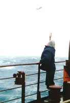
- the interaction between the underlying
ocean and the storm-track is also an area where better data and
better understanding are required; very little is known, for
example, about turbulent fluxes in the presence of extreme winds
at sea (Figure B, middle picture);
- a common meeting point of these topics
are the dynamical processes operating within cyclones and between
the cyclones and their environment, so that any aspect of the
cyclone problem has to, at some stage, deal with available cyclone
theories; it turns out that important changes have taken place
in this area in the past decade and the idea that cyclones result
from the spontaneous release of the instability of its environment
(in the sense of fluid dynamics) now appears to be a bit short
sighted (Figure C).
|
|
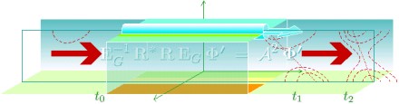 |
Figure C: this schematic
attempts to illustrate the current view of many atmospheric physics
theoreticians: cyclones result from the amplification, in favorable
areas such as the box in the centre of the drawing, of pre-existing
structures. These may be the debris of a previous event elsewhere,
which would be recycled in areas known as ``baroclinic zones'',
which are the atmospheric amplifiers. (Drawing by A. Joly, from
Météo-France.) |
|