
|
|
|
|
|
|
|
|||||||||
|
|||||||||
|
|
|||||||||
Key to maps and tables |
|||
|
|
|

|

|
|
|
Relevant weather systems trajectories, 6 hourly marks:
|
|
|
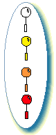
Other symbols for weather systems (from top to bottom):
|
|
|
Land radiosounding stations launch frequency (from top to bottom):
|

|
FASTEX-dedicated research ships, at their intensive sounding position (dot), from left to right: Ægir, Suroît, Knorr, Victor Bugaev. Arrow indicates ship displacement when this happened. |
|
|
Sketches of relevant flight tracks:
|
|
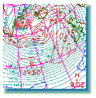
GOES and METEOSAT infra-red images, centered on the system of interest, extracted from the on-line Atlas. 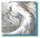
|
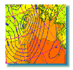 Operational ARPEGE (from Météo-France) analyses, extracted from the online Atlas, on the same area as the images. Continuous contours: mean sea level pressure, interval 5 mbar. Shading and dashed lines: 2m air temperature, interval 2°C. |
On occasions, this 850 mbar map (below) is shown. Light blue lines are geopotential. Red lines show absolute vorticity maxima, dark blue lines vorticity minima.
|
These images are accompanied by a short table describing the main steps of the life-cycle of the system of interest. This table is self-explicit.
The operations summary tables are meant to provide some details on the actions mentioned in the overview map.
The tables contain the following information:
| US-RS | date/time of change to 6h soundings of the US upper-air stations (or continuation symbol ® ) | date/time of change back to 12h soundings of the US upper-air stations (or continuation symbol ®) |
| Ship | date of mid-intensive sounding period | duration of intensive sounding period | approximate number of high-resolution profiles available in the Data Base for this period |
| time of mid-intensive sounding period |
|
||
| Aircraft | mid-flight date | flight duration | number of high-resolution profiles available in the Data Base |
| mid-flight time |
For Multiscale Sampling Area (MSA) flights: type of flight plans:
|
||
| European-RS | date/time of change to 3h soundings of the european upper-air stations (or continuation symbol ® ) | duration of the 3h soundings period. | number of stations involved in the sequence of 3h soundings. |
|
|
|
![]()
|
fastex-dba@cnrm.meteo.fr for questions or comments |
|
|